| ||||||||||
 

Dr. Ronald P. Rogers CHIROPRACTOR Support for your body's natural healing capabilities 270-384-5554 Click here for details 


Columbia Gas Dept. GAS LEAK or GAS SMELL Contact Numbers 24 hrs/ 365 days 270-384-2006 or 9-1-1 Call before you dig 
Visit ColumbiaMagazine's Directory of Churches Addresses, times, phone numbers and more for churches in Adair County Find Great Stuff in ColumbiaMagazine's Classified Ads Antiques, Help Wanted, Autos, Real Estate, Legal Notices, More... 


|
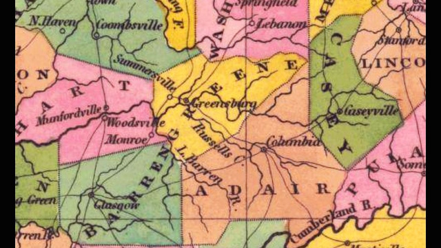
Very Old Person remembers big shift in Greene Co. population Charles Marshburn writes: I realize you are probably the only person old enough to remember why the population of Greene County fell 36% and the population of Adair County rose 17 % in the census of 1850. Hope it wasn't due to an election! Anyone with any information? - Charles MarshburnMr. Marshburn, I don't know. This is a question which has weighed on the minds of so many, so long, but you've just asked a question way beyond our collective educational level, though occurrences in the year 1948 may have something to do with the Greene County exodus. For Adair County, since this was before the influx of Canadian Tour Busses, it must have had to do with Malthusian reasons. But if there is a historian in the house, maybe we'll both learn the answer. - EW. For possibility's please ponder Larry Smith's ancient map we've linked by clicking on headline. This story was posted on 2015-04-21 06:04:59
Printable: this page is now automatically formatted for printing.
Have comments or corrections for this story? Use our contact form and let us know.
More articles from topic News:
Old Kentucky Home, Larry Smith visit album CACEDA meeting for today re-scheduled to 24 Apr 2015 Madison Co., KY man sentenced to 10 years for heroin conspiracy Trip to Cuba topic today on Susan and Carol Rosaline Beck, 81, Taylor Co., KY (1933-2015) Adair County Board of Elections Emergency Called Meeting Wed 22 Apr 2015 Gerald Doss: Post more policeman on Bypass Special called meeting Columbia City Council 21 Apr 2015 ACHS GRIT team projects extend beyond our community ACHS art students claim two first place awards, regionals View even more articles in topic News |
 

115 Jamestown St. Columbia, KY. 270-384-2496 


 Provided by the Adair Co Fiscal Court and the Adair Co. Emergency Mgt. Agency 


|
||||||||
|
| ||||||||||
|
Quick Links to Popular Features
Looking for a story or picture? Try our Photo Archive or our Stories Archive for all the information that's appeared on ColumbiaMagazine.com. | ||||||||||
|
Contact us: Columbia Magazine and columbiamagazine.com are published by Linda Waggener and Pen Waggener, PO Box 906, Columbia, KY 42728. Please use our contact page, or send questions about technical issues with this site to webmaster@columbiamagazine.com. All logos and trademarks used on this site are property of their respective owners. All comments remain the property and responsibility of their posters, all articles and photos remain the property of their creators, and all the rest is copyright 1995-Present by Columbia Magazine. Privacy policy: use of this site requires no sharing of information. Voluntarily shared information may be published and made available to the public on this site and/or stored electronically. Anonymous submissions will be subject to additional verification. Cookies are not required to use our site. However, if you have cookies enabled in your web browser, some of our advertisers may use cookies for interest-based advertising across multiple domains. For more information about third-party advertising, visit the NAI web privacy site.
| ||||||||||