| ||||||||||
 

Dr. Ronald P. Rogers CHIROPRACTOR Support for your body's natural healing capabilities 270-384-5554 Click here for details 


Columbia Gas Dept. GAS LEAK or GAS SMELL Contact Numbers 24 hrs/ 365 days 270-384-2006 or 9-1-1 Call before you dig 
Visit ColumbiaMagazine's Directory of Churches Addresses, times, phone numbers and more for churches in Adair County Find Great Stuff in ColumbiaMagazine's Classified Ads Antiques, Help Wanted, Autos, Real Estate, Legal Notices, More... 


|
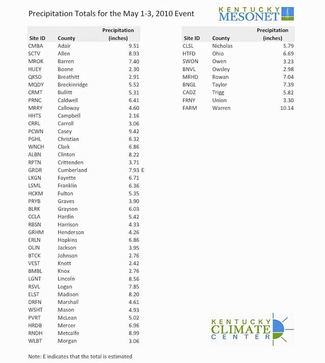
Kentucky Mesonet records historic rainfall event Adair County's 9.51" of precipitation 2nd highest of any of 49 Kentucky Mesonet recordings for May 1-3, 2010. Dr. Stuart Foster says historic event such as this happens only every 100-200 years. Click on headline for full story, chart News from Western Kentucky University Bowling Green, KY - The heaviest rain from this weekend's historic precipitation event fell across a corridor from Bowling Green to southeast of Lexington, according to data recorded by Kentucky Mesonet stations. The Mesonet station at the Western Kentucky University Farm recorded 10.17 inches of rain within 36 hours from Saturday morning to late Sunday afternoon. Second highest rainfall was recorded at Columbia, KY, in Adair County, with 9.51". Totals of more than 7 inches recorded at sites in Adair, Allen, Barren, Casey, Clinton, Cumberland, Lincoln, Logan, Madison, Metcalfe, Rowan Taylor counties Historic Event, Dr. Stuart Foster says "This was an historic event especially in the southern part of Kentucky," said Dr. Stuart Foster, state climatologist and director of the Kentucky Mesonet and the Kentucky Climate Center at WKU. "For the hardest hit areas, this type of event occurs every 100 to 200 years. Many of us will probably never see rainfall like this again." With 49 stations across Kentucky, the Mesonet was able to provide real-time data (updated every five minutes) as precipitation occurred Saturday and Sunday. "We were able to see what was happening as the event unfolded and provide that data to the National Weather Service and emergency management agencies," Dr. Foster said. "They didn't have to guess what was happening or have to wait until after the event to know what had happened. In the midst of a life-and-death situation, you want data you can trust." The data from the Mesonet also will be used in the aftermath of this weekend's event to determine the impact from flooding and to identify areas vulnerable to events of this type, Dr. Foster said. "Instead of waiting an hour later or a day later to see you had 2 inches of rain, you can see how quickly the 2 inches of rain fell," said Dr. Rezaul Mahmood, associate director of the Mesonet. Mesonet was of instant value "The Mesonet helped the users to determine the intensity of rainfall down to five-minute time-scale. The high density of network also allowed folks to accurately delineate the distribution of rainfall across the area. Both of these operational components are critical to emergency and recovery efforts." About the Kentucky Mesonet: Since the Mesonet's first station at the WKU farm in Warren County became operational in May 2007, 49 stations have been installed toward a goal of 100 stations statewide. The Mesonet stations collect real-time weather and climate data on temperature, precipitation, humidity, solar radiation, wind speed and direction. Data is packaged into observations and transmitted to the Kentucky Climate Center at WKU every five minutes, 24 hours per day, throughout the year and is available online at www.kymesonet.org. Stations are located in Adair, Allen, Barren, Boone, Breathitt, Breckinridge, Bullitt, Caldwell, Calloway, Campbell, Carroll, Casey, Christian, Clark, Clinton, Crittenden, Cumberland, Fayette, Franklin, Fulton, Graves, Grayson, Hardin, Harrison, Henderson, Hopkins, Jackson, Johnson, Knott, Knox, Lewis, Lincoln, Logan, Madison, Marshall, Mason, McLean, Mercer, Metcalfe, Morgan, Nicholas, Ohio, Owen, Owsley, Rowan, Taylor, Trigg, Union and Warren counties. Initial funding for the project was secured by U.S. Sen. Mitch McConnell through a $2.9 million federal appropriation for the Kentucky Climate Center, part of WKU's Applied Research and Technology Program in the Ogden College of Science and Engineering. This story was posted on 2010-05-08 06:04:40
Printable: this page is now automatically formatted for printing.
Have comments or corrections for this story? Use our contact form and let us know.
More articles from topic News:
Special News, Ads, for Saturday, May 8, 2010 Raising of Holladay Place Bowl tentatively set for May 28, 2010 Flood cleanup kits available for qualified homeowners Baby So Soft campaign now needs just 234.5 blankets! Adair student Breanna Dale on Noetic Math National Honor Roll Robert Flowers new member of Kosair Charities Board Goodens singing, special meal at Christie UMC Birthdays: Thanks to angels watching over CM Adair Co. Tire Amnesty program is in second day Today Purdy Baptist Church will have car wash View even more articles in topic News |
 

115 Jamestown St. Columbia, KY. 270-384-2496 


 Provided by the Adair Co Fiscal Court and the Adair Co. Emergency Mgt. Agency 


|
||||||||
|
| ||||||||||
|
Quick Links to Popular Features
Looking for a story or picture? Try our Photo Archive or our Stories Archive for all the information that's appeared on ColumbiaMagazine.com. | ||||||||||
|
Contact us: Columbia Magazine and columbiamagazine.com are published by Linda Waggener and Pen Waggener, PO Box 906, Columbia, KY 42728. Please use our contact page, or send questions about technical issues with this site to webmaster@columbiamagazine.com. All logos and trademarks used on this site are property of their respective owners. All comments remain the property and responsibility of their posters, all articles and photos remain the property of their creators, and all the rest is copyright 1995-Present by Columbia Magazine. Privacy policy: use of this site requires no sharing of information. Voluntarily shared information may be published and made available to the public on this site and/or stored electronically. Anonymous submissions will be subject to additional verification. Cookies are not required to use our site. However, if you have cookies enabled in your web browser, some of our advertisers may use cookies for interest-based advertising across multiple domains. For more information about third-party advertising, visit the NAI web privacy site.
| ||||||||||