| ||||||||||
 

Dr. Ronald P. Rogers CHIROPRACTOR Support for your body's natural healing capabilities 270-384-5554 Click here for details 


Columbia Gas Dept. GAS LEAK or GAS SMELL Contact Numbers 24 hrs/ 365 days 270-384-2006 or 9-1-1 Call before you dig 
Visit ColumbiaMagazine's Directory of Churches Addresses, times, phone numbers and more for churches in Adair County Find Great Stuff in ColumbiaMagazine's Classified Ads Antiques, Help Wanted, Autos, Real Estate, Legal Notices, More... 


|
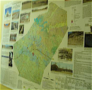
New Adair County geological map will help builders John Halsey of Knifley has written us that a new easy-to-understand geological map is now available from the Kentucky Geologic Service (KGS). The map was developed with non-geologists in mind, so it's easy for most people to understand. The map has many familiar photos from Adair County, along with lots of details (407 square miles, highest elevation 1,120 feet near Sparksville; lowest 585 feet where Russell Creek leaves the county, etc.) It gives strategies on pond construction, building constructions, details on wetlands, rock formations, radon in the county, Adair County is one of over 90 counties for which the new geologic maps are available. The map is a simplified land use map which should be an aid to anyone wanting to build in Adair County. A sample of the map is now on display in the hallway of County Judge Executive (CJE) Ann Melton's office. (Check the Adair County Public Library as well, they will likely have one.) The online map is awkwardly big and the download is quite slow. A full-color map, like the one in the CJE's office, can be ordered for $10, or, in laminated form, for $15.25 plus KY sales tax and shipping. To order, call the Kentucky Public Information Center at the University of Lexington in Lexington, KY (877) 778-7827. A copy of the map is online at a link he sent, Generalized Geologic Maps for Land-Use Planning Purposes. The download is very slow, even with cable or DSL. This story was posted on 2007-07-01 12:33:14
Printable: this page is now automatically formatted for printing.
Have comments or corrections for this story? Use our contact form and let us know.
More articles from topic News:
Hoover Family reunion, Jamestown, Sunday, Sept. 2, 2007 June 2007 Events for the Record JUNE 2007 Celebrations!: for the RECORD West Family Reunion Saturday, July 7, 2007 Adair Democratic Executive Board to plan Fair strategy Cheathams have lush town garden, despite drought Emily Griffitt Anderson murder: Link to June 29, testimony Link: Photos from groundbreaking for Columbia Western Bypass Send July 2007 news now Adair Fiscal Court special called meeting June 28, 2007 report View even more articles in topic News |
 

115 Jamestown St. Columbia, KY. 270-384-2496 


 Provided by the Adair Co Fiscal Court and the Adair Co. Emergency Mgt. Agency 


|
||||||||
|
| ||||||||||
|
Quick Links to Popular Features
Looking for a story or picture? Try our Photo Archive or our Stories Archive for all the information that's appeared on ColumbiaMagazine.com. | ||||||||||
|
Contact us: Columbia Magazine and columbiamagazine.com are published by Linda Waggener and Pen Waggener, PO Box 906, Columbia, KY 42728. Please use our contact page, or send questions about technical issues with this site to webmaster@columbiamagazine.com. All logos and trademarks used on this site are property of their respective owners. All comments remain the property and responsibility of their posters, all articles and photos remain the property of their creators, and all the rest is copyright 1995-Present by Columbia Magazine. Privacy policy: use of this site requires no sharing of information. Voluntarily shared information may be published and made available to the public on this site and/or stored electronically. Anonymous submissions will be subject to additional verification. Cookies are not required to use our site. However, if you have cookies enabled in your web browser, some of our advertisers may use cookies for interest-based advertising across multiple domains. For more information about third-party advertising, visit the NAI web privacy site.
| ||||||||||