| ||||||||||
 

Dr. Ronald P. Rogers CHIROPRACTOR Support for your body's natural healing capabilities 270-384-5554 Click here for details 


Columbia Gas Dept. GAS LEAK or GAS SMELL Contact Numbers 24 hrs/ 365 days 270-384-2006 or 9-1-1 Call before you dig 
Visit ColumbiaMagazine's Directory of Churches Addresses, times, phone numbers and more for churches in Adair County Find Great Stuff in ColumbiaMagazine's Classified Ads Antiques, Help Wanted, Autos, Real Estate, Legal Notices, More... 


|
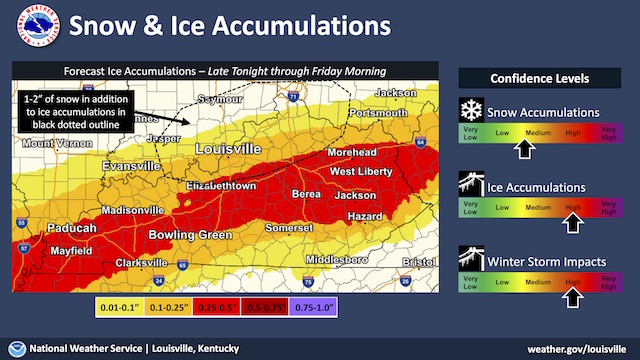
Mostly cloudy today, high 46F, Winter Storm Watch tonight It's currently 34F at the Adair County Mesonet station. Today will be mostly cloudy, with a chance of sprinkles and flurries before 8amCT, then a slight chance of rain between 8amCT and 11amCT. Today's high will be near 46F, with east wind 5 to 8 mph becoming north in the morning. Tonight will be cloudy, with a 40 percent chance of rain, mainly after 3amCT, and a low around 33F. Northeast wind 6 to 8 mph. The National weather Service in Louisville has issued a Winter Storm Watch from late tonight through Thursday evening. Heavy mixed precipitation will be possible. Total icing accumulations of one tenth to one half inch are likely and locally higher amounts will be possible. The heaviest icing is expected in a zone between the Western Kentucky and Bluegrass Parkways and the Cumberland Parkway. Wednesday will be cloudy again, with showers likely, mainly after noon, and a high near 42F. Northeast wind around 6 mph. Wednesday night will bring a 70 percent chance of rain showers before 2amCT, likely switching over to freezing rain. It will be cloudy, with a low around 29F and north wind 3 to 7 mph. This story was posted on 2021-02-09 06:04:04
Printable: this page is now automatically formatted for printing.
Have comments or corrections for this story? Use our contact form and let us know.
More articles from topic News:
7-County Area Courts for Tue 9 Feb 2021 LCDHD: Vaccination slots still open Video: Sunset with a Bonus Farmers Market has openings for vendors As COVID cases decline, state focuses on equitable vaccination Jail Committee Meeting, Thu 11 Feb 2021 US127 improvement study comment period ending soon Adair Co. Fiscal Court meeting agenda, Tue 9 Feb 2021 Homecoming 2021: a little bit of normal in pandemic Thank you to all who are helping JOY Ministries View even more articles in topic News |
 

115 Jamestown St. Columbia, KY. 270-384-2496 


 Provided by the Adair Co Fiscal Court and the Adair Co. Emergency Mgt. Agency 


|
||||||||
|
| ||||||||||
|
Quick Links to Popular Features
Looking for a story or picture? Try our Photo Archive or our Stories Archive for all the information that's appeared on ColumbiaMagazine.com. | ||||||||||
|
Contact us: Columbia Magazine and columbiamagazine.com are published by Linda Waggener and Pen Waggener, PO Box 906, Columbia, KY 42728. Please use our contact page, or send questions about technical issues with this site to webmaster@columbiamagazine.com. All logos and trademarks used on this site are property of their respective owners. All comments remain the property and responsibility of their posters, all articles and photos remain the property of their creators, and all the rest is copyright 1995-Present by Columbia Magazine. Privacy policy: use of this site requires no sharing of information. Voluntarily shared information may be published and made available to the public on this site and/or stored electronically. Anonymous submissions will be subject to additional verification. Cookies are not required to use our site. However, if you have cookies enabled in your web browser, some of our advertisers may use cookies for interest-based advertising across multiple domains. For more information about third-party advertising, visit the NAI web privacy site.
| ||||||||||