Dr. Ronald P. Rogers
CHIROPRACTOR
Support for your body's natural healing capabilities
270-384-5554
Click here for details
What's Going On
in Columbia?
see ColumbiaMagazine'sEvents List
Columbia Gas Dept.
GAS LEAK or GAS SMELL
Contact Numbers
24 hrs/ 365 days
270-384-2006 or 9-1-1
Call before you dig
Visit
ColumbiaMagazine's
Directory of Churches
Addresses, times,
phone numbers and more
for churches in Adair County
Find Great Stuff in
ColumbiaMagazine's
Classified Ads
Antiques, Help Wanted,
Autos, Real Estate,
Legal Notices, More...
|
|
JIM: As today, improved transportation was issue 100 years ago
Today the focus is on the Heartland Parkway, safer bridges, traversible country lanes, pathways for tourists, and highway safety, and transportation continues to be a key economic development issue. One hundred years ago it was on just being able from one point to another in one piece. Jim takes readers back to the issue as it stood in Crocus-to-Montpelier section of Adair and Russell Counties
By JIM
The following paragraphs, found in the Crocus newsletter published in the February 25, 1914 News, give a glimpse of the condition of some of the roads of that era -- and why News editor C.S. Harris fought so long and hard for improved transportation in Adair County.
George Helm's shop (he was a blacksmith) stood not far removed from the "T" intersection formed by modern day Hwy 92 and Rte 619. At that time, the Jamestown-Montpelier Road ran a bit farther north at that point than does today's Hwy 92.
Wrote the Crocus correspondent:
"A new country road is being opened between this place and Montpelier, along the line of the old neighborhood road leading from a point near Zion church to a point on Jamestown road, near Geo. Helm's shop.
"This bids fair to be a first-class highway, quite a contrast to the old one, which was only ever traversed by a few of the bravest of persons, owing to the danger from falling over the precipices or being crushed between the boulders."
Note for those starting in Columbia - Modern day travelers who want pack a lunch for a "Pickle Dog Picnic" and see and record sights mentioned. (Epicurean Kentuckian: A more perfect, Pickle-Dog centric, meal) and travel the roads, can sedately motor down 55 and hang a right onto 1313 to Crocus, to Crocus, then retrace the trek as far 55, crossing that highway to the Al Sullivan Road (Note: Google Maps says the road is "Al Sullivan Road," but the County Marker is "Turner Trail," which Adair County Addressing & Mapping Coordinator Zach Mann confirms is the official designation. - CM) (which becomes Cabin Fork Creek Road), crossing said creek before turning left onto Hwy 619, which in turn will take you to Rte 92, about 2/3rds of a mile east of downtown Montpelier. The trip from Crocus to Montpelier is a little under 5 miles. Thence, motor west on Montpelier Road to Highway 55 S Road at Zion, and hang a right to return to Columbia.
Subnote: Jim warns that if one overshoots 619 and finds themselves sailing across onto V. Blakey Road, "Don't panic," he says, "as that's a mighty short road. It leads to the most bucolic of scenes."
This story was posted on 2016-04-08 08:17:07
Printable: this page is now automatically formatted for printing.
Have comments or corrections for this story? Use our contact form and let us know.
Crocus-to-Montpelier Hwy: Starting point to get to starting point
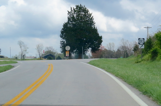
2016-04-09 - KY 55/KY 1313 near Crocus, Adair/Russell Counties, KY - Photo by Ed Waggener, CM photo.
JIM suggests, for the accompanying column, that travelers retracing the route of the big advance in Adair/Russell County transportation which took place over 100 years ago start at this landmark intersection. On the left, the road is Hwy 55 S Road, on the right, KY 1313, Crocus Road. He wants everyone to get the full impact of the historic community before taking the rest of the trek to Montpelier.
Read More... | Comments? | Click here to share, print, or bookmark this photo.
|
Crocus-to-Montpelier Hwy: Starting point, Pop. 16
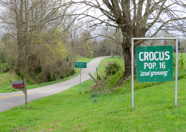
2016-04-09 - Adair-Russell Co. Line, Crocus Road, KY 1313 - Photo by Linda Waggener, CM photo.
This is the starting point for the Crocus-to-Montpelier Historic Highway progress story in the accompany article by Jim. Though the road above, beckons one to continue south to Bryan and Historic Creelsboro in Russell County, KY, this is the point to reverse course and retrace. The roads now best considered Slow Roads, but there will be a smooth ride all the way to Montpelier.
Read More... | Comments? | Click here to share, print, or bookmark this photo.
|
Retracing Crocus-to-Montpelier Hwy: The Miller/Spickard House
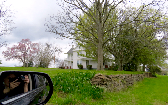
2016-04-09 - Crocus, KY - Photo by Ed Waggener, CM photo.
The 105 year old Spickard - or Miller - House begins Jim's update on history of a Main Road in Adair County, a big advance for transportation one hundred years ago. It was built in 1911. It is considered by many one of the most beautiful homes in Adair County. - Photo 8 Apr 2016. For an earlier look back at the the famous house, see: Built 100 years ago: Miller house at Crocus. - EW. To continue with Jim's retracing of the significance of the Crocus-to-Montpelier transportation breakthrough 100 years ago, click on Read More.
Read More... | Comments? | Click here to share, print, or bookmark this photo.
|
Lilac along the route of the Crocus-to-Montpelier highway
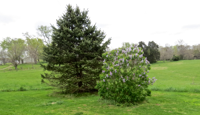
2016-04-09 - Crocus, KY - Photo by Linda Waggener, CM photo.
This lilac bush - in full bloom along the designated-by-Jim Crocus-to-Montpelier highway story retracing a development over 100 years ago - doesn't really fit in. Or does it make the point more than anything. If lilacs do nothing else, for most of us they bring back yesteryear. - LW
Read More... | Comments? | Click here to share, print, or bookmark this photo.
|
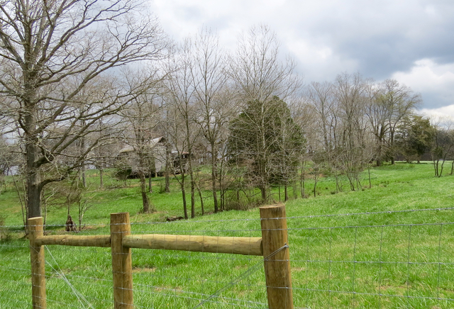
Crocus-to-Montpelier Hwy: Re-start point, Turner Trail
2016-04-10 - Intersection of Hwy 55 S Road & Turner Trail, from Crocus Road - Photo by Ed Waggener, CM photo.
We re-traced Jim's instructions for the route of his Crocus to Montpelier Highway, the big breakthrough in infrastructure in 1913, today, Sunday, April 10, 2016 to get a better perspective. Turner Trail is the road by the dogwood tree, passing by the Sullivan home top center of the photo. This road intersects with Cabin Creek Road, where re-enactors make a left turn.
Read More... | Comments? | Click here to share, print, or bookmark this photo.
|
Crocus-to-Montpelier Hwy: Along Turner Trail
2016-04-11 - Turner Adair County, KY - Photo by Ed Waggener, CM photo.
A nostalgic look along the Turner Trail leg of the route retracing what was a major advance in transportation over 100 years ago, what was then a modern roadway connecting the important South Adair County Communities of Crocus and Montpelier. - EW
Read More... | Comments? | Click here to share, print, or bookmark this photo.
|
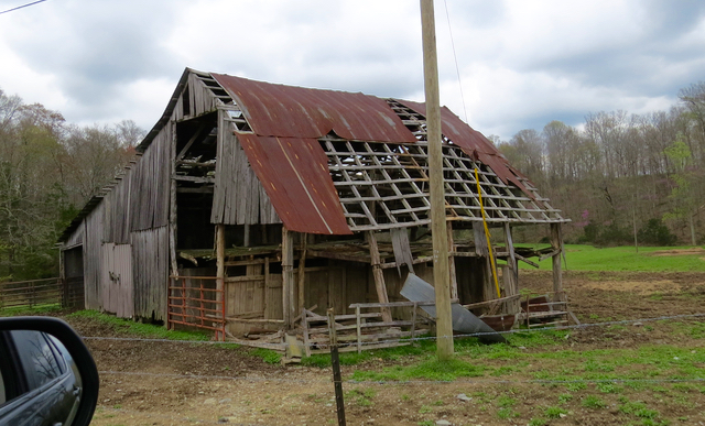
Crocus-to-Montpelier Hwy: Along Turner Trail, old home
2016-04-11 - Turner Trail, Adair County, KY - Photo by Ed Waggener.
Standing in sacred respect for what must have been an important part of a family's history, a graying house from yesteryear warms the way along Al Sullivan Road, while modern fencing, and lush pasture land demonstrate how well modern agriculture thrives alongside for days of the past. Whether the old house was standing in the age of Jim's story retracing a great story about the Crocus-to-Montpelier highway advance, is a question for others. The photo above was taken Friday, April 8, 2016, as Redbud trees were peaking and the gorgeous countryside was just hinting of dogwoods. - EW
Read More... | Comments? | Click here to share, print, or bookmark this photo.
|
Crocus-to-Montpelier Hwy: Turner Trail at Cabin Creek Road
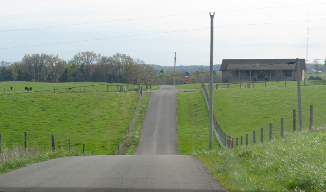
2016-04-11 - Turner Trail and Cabin Creek Road, Adair Co., KY - Photo by Ed Waggener, CM photo.
A critical juncture in the Crocus-to-Montpelier road way. JIM warns that the old roadway takes a left, at the well marked intersection. But the consequences are actually quite pleasant if one does over jump Cabin Creek Road.
Read More... | Comments? | Click here to share, print, or bookmark this photo.
|
Crocus-to-Montpelier Hwy: Failing to make turn. V Blakey Road
2016-04-11 - V Blakey Road, Russell Co., KY - Photo by Ed Waggener, CM photo.
This is off the Crocus-to-Montpelier historic roadway. The the writer of the accompanying piece recalls that it is one of the most beautiful bucolic farmstead scenes in America - and indeed, in this photo taken April 8, 2016, it is.
Read More... | Comments? | Click here to share, print, or bookmark this photo.
|
Crocus-to-Montpelier Hwy: Cabin Creek Road at KY 92
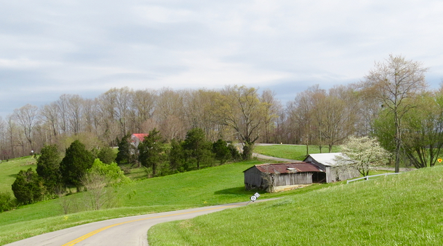
2016-04-11 - Cedar Creek Road, Russell County, KY side of Montpelier - Photo by Ed Waggener, CM photo.
As the Crocus-to-Montpelier Historic Highway is retraced today, the approach to last turn along the way is above. This area was once a part of Adair County, KY, and was once the site of the Montpelier Post Office, which was moved west by one of its early postmasters, possibly to put it back in the county of its origin. The peak of the hill, and Cedar Creek Road offer grand views of the well maintained, but no longer active, business district of Montpelier.
Read More... | Comments? | Click here to share, print, or bookmark this photo.
|
Crocus-to-Montpelier Hwy: Montpelier from Cabin Creek Road
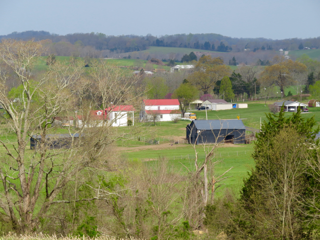
2016-04-11 - Cabin Creek Road, Russell Co., KY - Photo by Ed Waggener.
An often viewed but not so frequently photographed view of the historic community of Montpelier, KY, seen above from Cabin Creek Road, in Russell County. It's near the terminus of the transportation breakthrough over 100 years ago, when the Adair County Fiscal Court established the roadway connecting the important trading communities of Crocus and Montpelier. Photo Mon 11 Apr 2016. - EW
Read More... | Comments? | Click here to share, print, or bookmark this photo.
|
Crocus-to-Montpelier Hwy: Another view of Montpelier
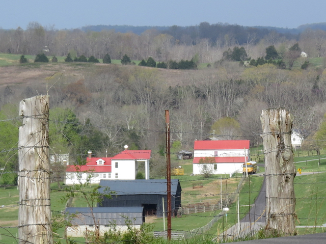
2016-04-11 - KY 92, Russell County, KY, at Montpelier - Photo by Ed Waggener.
Finally, on the Main Road to Montpelier, a view from KY 92, from Russell County, in the last leg of the the route retracing the historic Crocus-to-Montpelier Hwy. Between the posts, the campus of a charming, captivatingly maintained monument to yesteryear. To the right in the fencepost frame, the light and dark pavement marks the Adair-Russell County line. The Russell County line sign can be seen just left of the highway. - EW. Photo Mon 11 Apr 2016
Read More... | Comments? | Click here to share, print, or bookmark this photo.
|
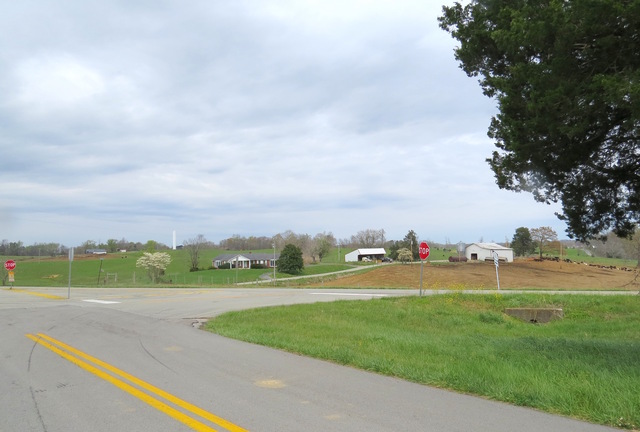
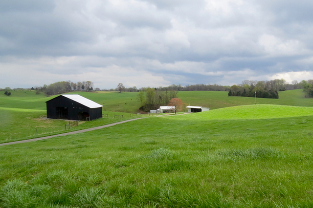
Crocus-to-Montpelier Hwy: Historic Montpelier
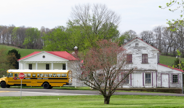
2016-04-11 - Montpelier, Adair Co., KY - Photo by Ed Waggener.
Montpelier, KY, today, Monday, April 11, 2016. The eastern terminus of the historic highway, built over 100 years ago, connecting Adair County communities Crocus and Montpelier. - EW
Read More... | Comments? | Click here to share, print, or bookmark this photo.
|
|
|

115 Jamestown St.
Columbia, KY.
270-384-2496
Get weather alerts for Adair County

Provided by the Adair Co Fiscal Court and the Adair Co. Emergency Mgt. Agency
|