| ||||||||||
 

Dr. Ronald P. Rogers CHIROPRACTOR Support for your body's natural healing capabilities 270-384-5554 Click here for details 


Columbia Gas Dept. GAS LEAK or GAS SMELL Contact Numbers 24 hrs/ 365 days 270-384-2006 or 9-1-1 Call before you dig 
Visit ColumbiaMagazine's Directory of Churches Addresses, times, phone numbers and more for churches in Adair County Find Great Stuff in ColumbiaMagazine's Classified Ads Antiques, Help Wanted, Autos, Real Estate, Legal Notices, More... 


|
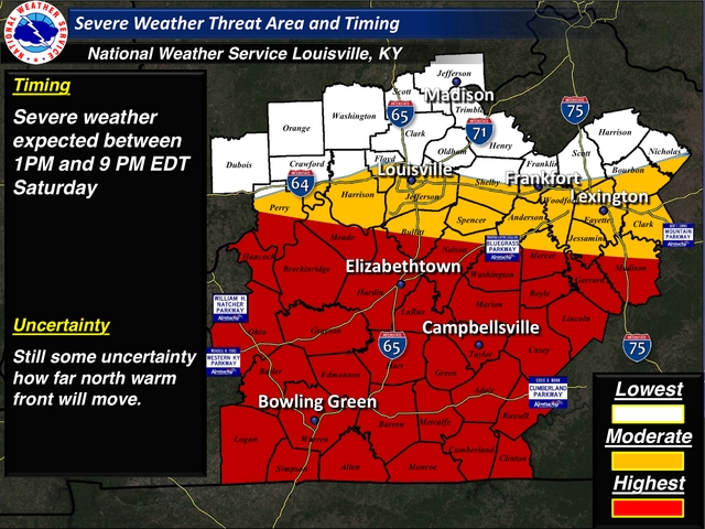
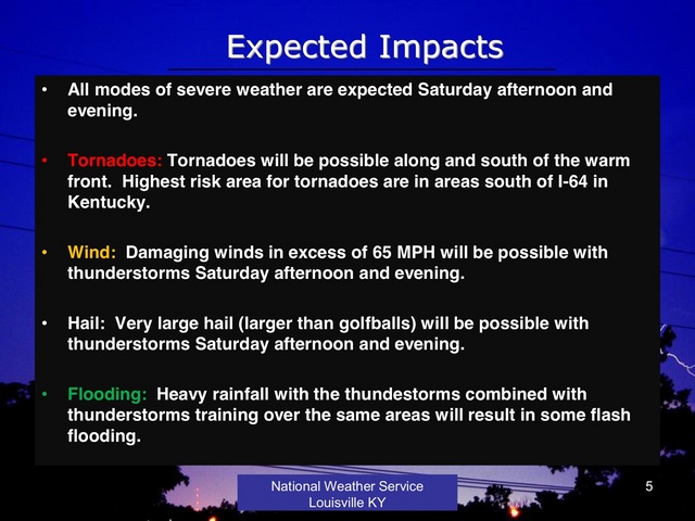
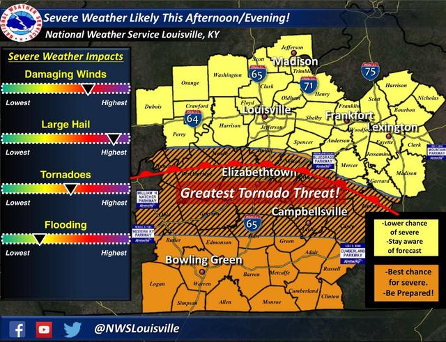
Severe weather threat Saturday, April 25, 2015 By Mike Keltner, Emergency Management Director After attending a conference call with the National Weather Service this afternoon I wanted to share the information they provided with the citizens of Adair County. NWS Meteorologist Joe Sullivan stated that this will be our 1st real risk for severe weather in 2015. Severe Weather is expected between 12pm Noon CT and 8pmCT, - All modes of severe weather are expected Saturday afternoon and evening.Outdoor Warning Sirens will be activated from the Adair Co. 911 Center in the event of a tornado warning from the NWS, a creditable spotting of a tornado / funnel cloud, a storm threatening lives or creating significant property damage to residents of Adair County. Code Red Alert Calling will include Tornado Watches and Warnings. Tornadoes can occur in a split second please be aware of the weather conditions in your area during a tornado watch. Also, take note that a Code Red call may be delayed or fail if infrastructure (phone lines - cell towers) are damaged. - MIKE KELTNER, Adair County Emergency Management Director This story was posted on 2015-04-24 15:18:43
Printable: this page is now automatically formatted for printing.
Have comments or corrections for this story? Use our contact form and let us know.
More articles from topic News:
Writer relates danger for inmates working on highway Mayor Hardwick: Paperwork in for him to be Mayor by Tue ACHS taking nominations for 2015-16 Site Council Fundraiser benefits newly formed Russell Co. HonorGuard Janie Kaye Morgan, Green County, KY (1952-2015) Dr. Luckey: Time for LWC to get scared of its dreams Second Christian Fish Fry is Fri 24 Apr 2015 Adair EMD Mike Keltner: Freeze Warning 9 Apr 2015 from NWS Bobby Dunbar, at Victory A.D.O. 24 Apr 2015 Jon Halsey: No need for employees to go without checks View even more articles in topic News |
 

115 Jamestown St. Columbia, KY. 270-384-2496 


 Provided by the Adair Co Fiscal Court and the Adair Co. Emergency Mgt. Agency 


|
||||||||
|
| ||||||||||
|
Quick Links to Popular Features
Looking for a story or picture? Try our Photo Archive or our Stories Archive for all the information that's appeared on ColumbiaMagazine.com. | ||||||||||
|
Contact us: Columbia Magazine and columbiamagazine.com are published by Linda Waggener and Pen Waggener, PO Box 906, Columbia, KY 42728. Please use our contact page, or send questions about technical issues with this site to webmaster@columbiamagazine.com. All logos and trademarks used on this site are property of their respective owners. All comments remain the property and responsibility of their posters, all articles and photos remain the property of their creators, and all the rest is copyright 1995-Present by Columbia Magazine. Privacy policy: use of this site requires no sharing of information. Voluntarily shared information may be published and made available to the public on this site and/or stored electronically. Anonymous submissions will be subject to additional verification. Cookies are not required to use our site. However, if you have cookies enabled in your web browser, some of our advertisers may use cookies for interest-based advertising across multiple domains. For more information about third-party advertising, visit the NAI web privacy site.
| ||||||||||