| ||||||||||
 

Dr. Ronald P. Rogers CHIROPRACTOR Support for your body's natural healing capabilities 270-384-5554 Click here for details 


Columbia Gas Dept. GAS LEAK or GAS SMELL Contact Numbers 24 hrs/ 365 days 270-384-2006 or 9-1-1 Call before you dig 
Visit ColumbiaMagazine's Directory of Churches Addresses, times, phone numbers and more for churches in Adair County Find Great Stuff in ColumbiaMagazine's Classified Ads Antiques, Help Wanted, Autos, Real Estate, Legal Notices, More... 


|
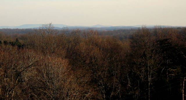
Kentucky Color: Clinton and Wayne Co., KY hills From Mark Parrish's yard, one can see Burchett Mountain in Clinton Co., KY, and mountains in Wayne Co., KY. The next earlier Kentucky Color is Frost Flowers seen at Chowning Farm Amandaville, Cumberland Co., KY By Billy Joe Fudge, President Homeplace on Green River, 6035 New Columbia RD, Campbellsville, KY In an earlier photo Kentucky Color: Smokey Mountains North we looked East from the intersection of KY 768/Sparksville RD, (Harvey's Ridge Road) and KY 61 to see the Green River Knob, elevation 1789 feet, over near the Casey, Russell, and Pulaski County Lines. The view in the accompanying photograph is from Mark Parrish's yard, elevation 1095 feet, just a half mile out Harvey's Ridge Road from KY 61. In the right foreground is the thin green of Virginia Scrub Pine. To the left and back in the woods is the darker, dense green of Eastern Red Cedar. Looking up on the horizon just to the right of center is a pointed peak which is Burchett Mountain (elevation 1525 feet) in Clinton County. Just behind Burchett Mountain about 2 miles on to the South South East is Albany. Of course the Tennessee, Kentucky State Line is only about 5 or 6 miles beyond. From this vantage point we are looking down Rock Lick Creek across the Jay Wheeler Farm and then the Dearing Fletcher Place where Rock Lick runs into Harrods Fork of Crocus Creek. The line of sight then crosses Chestnut Flat Ridge, Crocus Creek just above Amandaville, Irish and Lawson Bottoms on the Cumberland River, and Hwy. 90 just South of Seventy Six Falls at the head of Indian Creek on Lake Cumberland. Burchett Mountain is flanked to the East on the left by Sewell and Poplar Mountains (elevation near 1800 feet in places). On to the left of Sewell and Poplar Mountains are Taylor and Edwards Mountains (elevation around 1600 and 1700 respectively) just South of Monticello in Wayne County. This story was posted on 2009-12-20 07:08:59
Printable: this page is now automatically formatted for printing.
Have comments or corrections for this story? Use our contact form and let us know.
More articles from topic Kentucky Color by Billy Joe Fudge:
Kentucky Color: Rare sight. Patch of frost flowers Kentucky Color: Gilled mushrooms, Harvey's Ridge, KY Kentucky Color: Sugar Maple leaves have wide color variation Kentucky Color: Southern Red Oaks brighten Fairground ST Kentucky Color: White Oak Kentucky Color: Tic Tac Toe in the sky Kentucky Color: Smoky Mountains North Kentucky Color: Sassafras foliage has unique orange Kentucky Color: Prickly Ash, cloudy purple in fall Kentucky Color: Poison Beauty (Poison Ivy) View even more articles in topic Kentucky Color by Billy Joe Fudge |
 

115 Jamestown St. Columbia, KY. 270-384-2496 


 Provided by the Adair Co Fiscal Court and the Adair Co. Emergency Mgt. Agency 


|
||||||||
|
| ||||||||||
|
Quick Links to Popular Features
Looking for a story or picture? Try our Photo Archive or our Stories Archive for all the information that's appeared on ColumbiaMagazine.com. | ||||||||||
|
Contact us: Columbia Magazine and columbiamagazine.com are published by Linda Waggener and Pen Waggener, PO Box 906, Columbia, KY 42728. Please use our contact page, or send questions about technical issues with this site to webmaster@columbiamagazine.com. All logos and trademarks used on this site are property of their respective owners. All comments remain the property and responsibility of their posters, all articles and photos remain the property of their creators, and all the rest is copyright 1995-Present by Columbia Magazine. Privacy policy: use of this site requires no sharing of information. Voluntarily shared information may be published and made available to the public on this site and/or stored electronically. Anonymous submissions will be subject to additional verification. Cookies are not required to use our site. However, if you have cookies enabled in your web browser, some of our advertisers may use cookies for interest-based advertising across multiple domains. For more information about third-party advertising, visit the NAI web privacy site.
| ||||||||||